

Contents 30
Overview
Tenerife is the largest of the Canary Islands and home to Teide, a 3,715 m volcano that remains the highest point in Spain and in the whole Atlantic. Within 80 km the island holds two opposite climates: a damp, green north and an arid, sunny south.
Tenerife is an island with two faces, sitting off the coast of Morocco, four and a half hours by plane from France. At its centre, Teide rises to 3,715 m and punches through the cloud layer. All around, the vegetation changes every twenty kilometres of road.
The north catches the damp trade winds. It carries laurel forests, colonial villages, banana plantations and genuine black-sand beaches. The south sits in the shelter of the mountains: clear skies almost all year, big beach resorts, water at 20 °C in winter.
This island is not a simple beach holiday, then. You can hike through a relic forest from the Tertiary period in the morning and walk on volcanic gravel at 3,500 m in the afternoon.
- Status: Spanish island, autonomous community of the Canary Islands
- Airports: Tenerife Sur (TFS) and Tenerife Norte (TFN), 60 km apart
- Currency: euro, with a local sales tax (IGIC) at 7%
- Language: Spanish (little English spoken outside the resorts)
- Time difference: -1 hr from Paris (same time as London)
12 places to take with you
In the guide's order, ready for Google Maps or your GPS.
Book the activities from this guide
Our picks for Tenerife, well rated and free to cancel.
-
Book this activity
Whale watching on a Barco Azul boat from Los Cristianos or Puerto Colón
EUR 25-60 per adult depending on length and boat type, drink often included
-
Book this activity
Colonial northern loop: La Orotava, Icod de los Vinos and Garachico
EUR 25-40 per person, fuel and lunch included, car hire excluded
-
Book this activity
Hiking in the laurel forest of Anaga
Free, excluding transport or shuttle
Affiliate links: Travel Advice earns a commission if you book, at no extra cost to you. Learn more

Teide National Park and Pico del Teide
You round one last bend and the scenery changes in an instant: no more trees, no more noise, just ochre and black lava flows rising towards a perfect cone.
Pico del Teide reaches 3,715 m. It is the highest point in Spain and in the whole Atlantic, standing at the centre of a caldera 17 km across. The park has been a UNESCO World Heritage site since 2007.
You visit in a loop from the TF-21 road. You walk the circuit of the Roques de García, eroded monoliths towering over the plain, in 1 hr 30 to 2 hours. You stop at the Llano de Ucanca, a vast pale plain that is spectacular late in the day. Allow a full day for the whole thing.
No other volcano in Europe can be visited like this: the road runs through the crater itself, which puts the landscapes within reach even without long walks.
The classic mistake is assuming the permit is still free and chancing it on arrival. Book your slot several weeks ahead, take the first one of the morning, and keep the confirmation: it is checked at the trailhead.

Anaga Rural Park
The trunks are covered in moss, mist drifts between the branches, and you can hear water dripping off the leaves: an hour from the southern beaches, you are walking through a primary forest.
Anaga has been a UNESCO biosphere reserve since 2015. The massif is 7 to 9 million years old, making it the oldest part of the island. Its laurisilva (laurel forest) is a relic of the Tertiary, when such forests covered the Mediterranean basin, and it shelters more than 100 endemic species.
People come to walk the Sendero de los Sentidos, three short waymarked loops starting from Cruz del Carmen, to climb to the Pico del Inglés viewpoint, then to drop down to the cave hamlet of Chinamada, whose houses are carved into the rock. Half a day minimum, a full day if you add the beaches.
It is the exact counterpoint to Teide: where the volcano is mineral and dry, Anaga is damp, dense and green. It can be up to 10 °C cooler here than in Los Cristianos.
To choose: the Sendero de los Sentidos suits families and sturdy pushchairs, while the descent to Chinamada needs proper shoes and a good two hours. The roads in Anaga are narrow and twisting, so allow double the time your GPS shows.

Teleférico del Teide and La Rambleta
Eight minutes in a cabin, and the air turns dry, cold and faintly sulphurous: you are already above the clouds.
The cable car links the lower station, at 2,356 m, to La Rambleta, at 3,555 m. One detail saves a lot of disappointment: this is not the summit. There are still about 160 m of ascent to the crater, reachable only on foot and only with a permit.
From the arrival platform, two short free trails lead to the viewpoints of Pico Viejo, facing the gaping mouth of the second crater, and La Fortaleza, looking north across the island. Allow 30 to 45 minutes of easy walking for either.
It is the only way to reach this altitude without a five-hour climb, which makes it the obvious choice for families and for visitors short on time.
The cable car closes without warning in high winds, mid-summer included, and refunds are settled at the ticket office. Take the earliest possible slot, while the wind is still light, and keep a ground-level plan B for the same day.

San Cristóbal de La Laguna
Here the streets run straight, the façades are pastel, the courtyards stand open, and the sound of student terraces replaces the rattle of wheelie suitcases.
The island's former capital, La Laguna has been a UNESCO World Heritage site since 1999. The reason: it is the first unfortified colonial town built on a grid plan, an urban model later exported across Latin America.
You explore on foot, in a pedestrianised centre. You walk up calle San Agustín and calle Obispo Rey Redondo, push open the doors of the courtyard houses, and stop at the cathedral and the church of La Concepción. Two to three hours is enough, coffee included.
It is the liveliest town on the island, the one where you eat local rather than touristy, only 40 minutes by tram from Santa Cruz.
A common mistake is treating La Laguna as a one-hour stop. Pair it with the entrance to Anaga park, twenty minutes' drive away, for a full day in the north.

Garachico and the natural pools of El Caletón
Turquoise water sits still in basins of jagged black rock, while Atlantic waves explode into foam just behind the rim.
These pools are not natural by accident. On 5 May 1706, the Trevejo volcano, also known as Montaña Negra, erupted above the village. The flows advanced for 40 to 58 days and buried the island's most prosperous port, yet there was not a single casualty. The basins of El Caletón are that lava, cooled by the ocean.
You swim between basalt walls, visit the little fort of San Miguel that survived, then wander the rebuilt lanes and the shaded main square. Half a day, swimsuit included.
Elsewhere you look at lava; here you swim in it, and the village tells the story with dates rather than vague signboards.
The basins are sharp and slippery: water shoes solve the problem for about ten euros. If the sea is breaking hard, do not push it and head back up into the village, whose squares are worth the detour on their own.

Whale watching in the franja Teno-Rasca
The engine cuts, silence falls, and twenty metres off the side a round black fin slices the water without hurrying.
This 22 km marine strip between the headlands of Teno and Rasca became Europe's first Whale Heritage Site in January 2021, a label awarded by the World Cetacean Alliance. It is home to about 200 resident short-finned pilot whales and bottlenose dolphins, present 365 days a year. Up to 21 species of cetacean have been recorded here.
You board at Los Cristianos or Puerto Colón for 2 to 5 hours depending on the package, usually with a swim stop at anchor and a run past the Los Gigantes cliffs on the way back.
Few places in the world guarantee resident cetaceans less than an hour's sailing from port: here, there is no season to wait for.
Go in the morning: in the afternoon the trade wind rises and the sea gets choppy, which spoils the watching and brings on seasickness. A sailing boat or a small catamaran, being quieter, delivers better encounters than a big motor boat.

La Orotava
You push open a studded door and find yourself in a cool courtyard full of ferns, ringed by dark wooden galleries: the town hides its finest interiors.
La Orotava is Tenerife's aristocratic town, built by families enriched first by sugar, then by wine. The Casa de los Balcones, from the 17th century, is its emblem, with its carved Canarian wooden balconies and its two-storey courtyard.
The visit is a walk uphill through steep cobbled streets: courtyard houses, terraced gardens, and the Humboldt viewpoint taking in the whole valley down to the ocean. Two hours, a little more if you go inside the mansions.
Unlike its seaside neighbour Puerto de la Cruz, La Orotava was never reshaped by tourism: it is the best-preserved historic centre on the northern slope.
To pick your base in the north: sleep in Puerto de la Cruz for the sea and the restaurants, but give a whole morning to La Orotava, ten minutes' drive away. Tacking it on at the end of the day, once the historic houses have closed, is the most common mistake.

Puerto de la Cruz and Playa Jardín
The sand is properly black, almost charcoal, and it heats up fast underfoot. Behind it, palm trees and waterfalls run down to the beach.
Puerto de la Cruz was the archipelago's first tourist resort. Its flagship beach, Playa Jardín, lines up 700 m of genuine black volcanic sand across three coves: Castillo, Charcón and Punta Brava. The gardens and waterfalls that border it were designed by the Lanzarote artist César Manrique in the 1990s.
You alternate between swimming, walking the seafront and, right next door, the saltwater pools of Lago Martiánez, another Manrique creation, ideal on days with a heavy swell. Half a day passes effortlessly.
It is the island's only large black beach that is lifeguarded, properly equipped and reachable on foot from a town centre.
Come in the morning, when the northern sky is clearest and the sand still warm rather than hot. In the middle of the day, black sand becomes scorching: sandals really do help.

Masca and its barranco
The hamlet appears all at once at the end of the hairpins, clinging to a ridge, with palm trees planted over the void and crests cut out against the light.
Masca is a village of a few houses perched at 750 m in the Teno massif, one of the oldest parts of the island. The barranco descent starts from there: about 5 km, 4 hours, 750 m of descent through a deep gorge down to the ocean.
You make your way between walls hundreds of metres high, scramble down rock steps, and come out on a small pebble beach where the boat collects the walkers. The village on its own, with its viewpoints and its clifftop restaurant terrace, takes an hour to see.
This is Tenerife's signature hike, but also its most tightly controlled: better to plan it than to discover the rules on arrival.
Closed mountain boots are checked at the entrance: in city trainers or sandals you will be turned away with no refund. Book several weeks ahead, and if the slots are full, settle for the village and the road of viewpoints, which already offer the finest views.

Acantilados de Los Gigantes
Seen from a boat, the basalt wall dwarfs everything: the bow looks tiny, and the cliff throws the engine noise back at you like the wall of a cathedral.
These "cliffs of the giants" drop sheer into the Atlantic for nearly 600 m, on the western flank of the Teno massif. The rock is basalt, streaked vertically by erosion.
The only real way to see them is from the water: catamaran, rigid inflatable or kayak from the harbour at Los Gigantes or from Los Cristianos. Allow 2 to 3 hours, often with a swim at the foot of the wall.
From land you only make out an edge. From the water you grasp the scale, which is why the trip is nearly always combined with whale watching.
Rather than a cliffs-only excursion, take a combined whales and Los Gigantes trip: same boat, same area, and the price per hour at sea drops sharply. If you go by kayak, book the guided version, as the currents near the wall are not to be taken lightly.

Playa de las Teresitas
Blond sand, neat rows of palm trees, water as flat as a lake: the island's most photographed beach looks nothing like the rest of Tenerife.
And for good reason: this is not black sand. Around 270,000 tonnes of golden sand were imported from the Western Sahara between the late 1960s and 1973 to create the beach. A breakwater roughly 1 km long cuts the swell and holds the sand in place.
The result: calm, shallow water, sun loungers, kiosks and car parks a few minutes from Santa Cruz. You can spend half a day here with the family without ever watching the waves.
It is the safest beach for children near the capital, as long as you know what you are coming for: comfort, not volcanic authenticity.
Do not count on it for black sand: for that you need El Bollullo, Benijo or Playa Jardín. Las Teresitas is the right call with young children or a weak swimmer, not for a wild atmosphere.

Playa de Benijo
The sand really is black, the cliff closes off the horizon, and the crash of the waves drowns out voices: nobody is selling mojitos here.
This is Tenerife's genuine black-sand beach, still wild beneath the northern cliffs. Benijo sits right at the end of the Anaga road, facing the jagged roques that rise out of the water. Its cousin El Bollullo is reached on foot from the banana plantations above Puerto de la Cruz, 33 km from here and on an entirely different outing.
You come down to walk along the water, photograph the roques at sunset, and eat fish in the handful of restaurants perched above. Allow half a day with the drive, more if you follow it with a trail in Anaga.
No other beach on the island combines this cliff setting, this sand and this complete lack of facilities, which is also where the risk comes from.
Come late in the afternoon for the light on the roques of Benijo, but leave before dark: the paths down are steep and unlit. Bring water and a snack, as there is no shower and no shop on the sand.
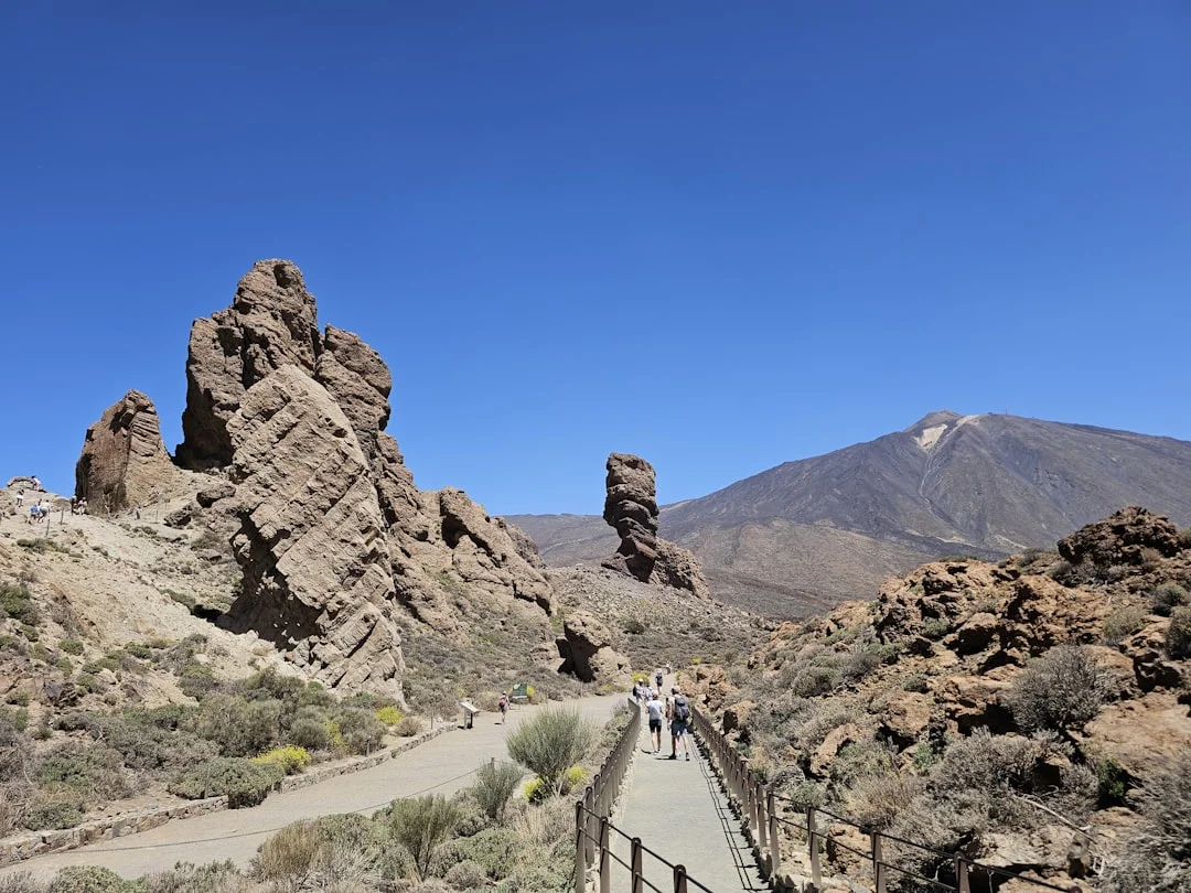
Climbing Teide at sunrise, from the cable car to the crater
First cable car of the morning, 8 minutes in the cabin up to La Rambleta at 3,555 m, then trail 10, known as Telesforo Bravo, 40 to 60 minutes there and back on volcanic gravel to the crater rim at 3,715 m. At the top, the smell of sulphur rises from the fumaroles and the volcano casts its pyramid-shaped shadow over the ocean and the neighbouring islands.
A short but genuine effort at this altitude, not advised with heart or breathing problems: pack a fleece, a windproof layer, sunscreen and water. Two separate bookings are compulsory, the cable car ticket on one side and the trail 10 permit on the Tenerife ON platform on the other, several weeks ahead in high season.
- Half a day, including 40 to 60 min of walking there and back above La Rambleta
- EUR 42 cable car return, non-resident adult + EUR 15 trail 10 ecotax (non-resident)
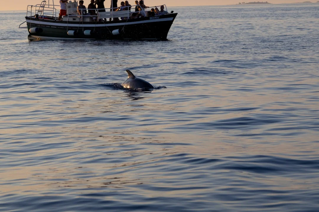
Whale watching on a Barco Azul boat from Los Cristianos or Puerto Colón
You board at the harbour in the morning, head offshore into the Teno-Rasca marine strip, then the engine cuts as soon as a group is spotted. The 200 resident short-finned pilot whales and the bottlenose dolphins often let boats approach within a few dozen metres. Longer packages add a swim stop at anchor and a return along the foot of the Los Gigantes cliffs.
Suitable for everyone, children included, on a sea that is usually calm in the morning. Insist on a boat carrying the "Barco Azul" label, the guarantee that approach distances are respected, book online the day before in high season, and take a cap, sunscreen and a windproof layer.
- 2 to 5 hours depending on the option
- EUR 25-60 per adult depending on length and boat type, drink often included
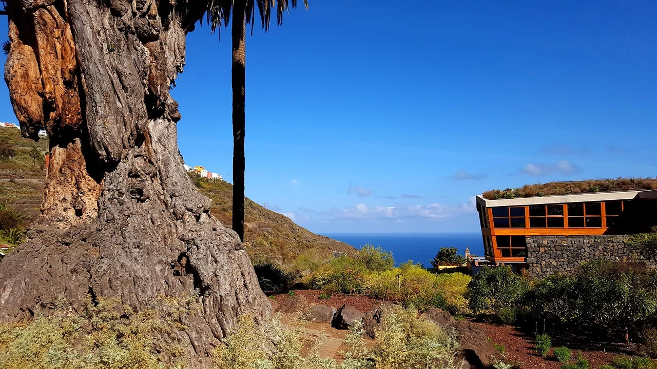
Colonial northern loop: La Orotava, Icod de los Vinos and Garachico
An early start from Puerto de la Cruz, up to La Orotava for its courtyards and its 17th-century wooden balconies, then on to Icod de los Vinos and its Drago Milenario, the archipelago's emblematic dragon tree. The afternoon drops down to Garachico, where you swim in the basins of El Caletón, the lava of the 5 May 1706 eruption cooled by the ocean. The thread running through the day is economic: sugar, then malmsey wine, then the flow that swallowed the port.
An easy day, family-friendly, but with plenty of uphill walking and winding roads. A car is essential, pack a swimsuit and water shoes, and have lunch in a guachinche on a weekday rather than at a seafront restaurant.
- A full day
- EUR 25-40 per person, fuel and lunch included, car hire excluded
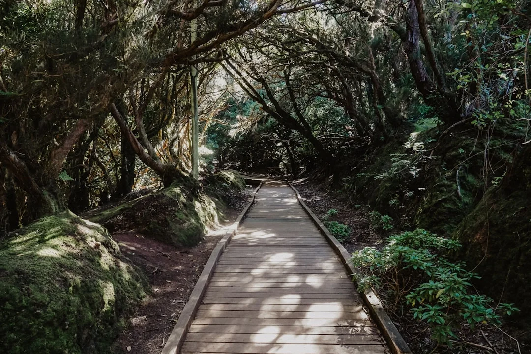
Hiking in the laurel forest of Anaga
Start from Cruz del Carmen, where the Sendero de los Sentidos offers three short waymarked loops through the laurel forest, then pick a longer route to the Pico del Inglés viewpoint or the descent to the cave hamlet of Chinamada. The high point comes when the mist drifts between the moss-covered trunks of a relic Tertiary forest, 7 to 9 million years old.
The short loops suit families, while the descents to the coast call for stamina and properly gripped shoes, as the ground stays slippery. There is no entrance fee: come early by car or by bus from La Laguna, with a fleece, water and a picnic, because shops are scarce.
- 2 to 6 hours depending on the trail
- Free, excluding transport or shuttle
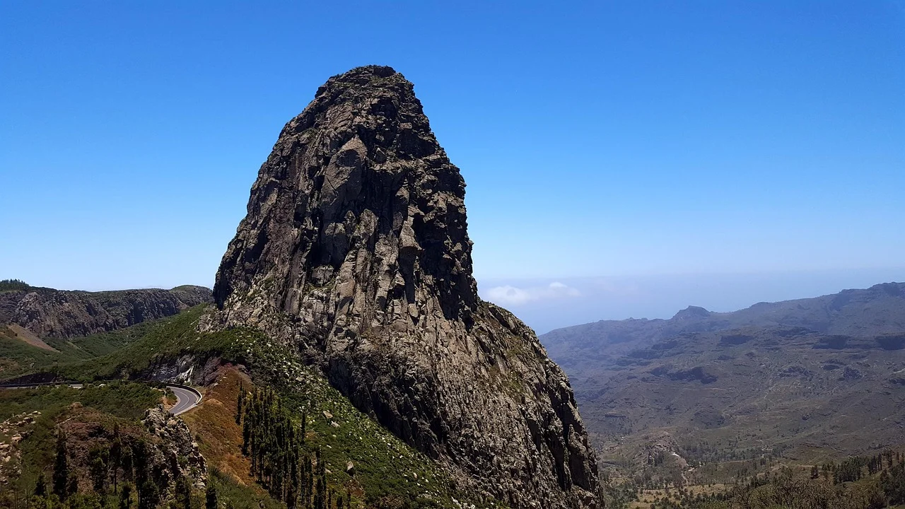
A day trip to La Gomera by ferry
Board the first ferry out of Los Cristianos, 50 minutes of crossing to San Sebastián de La Gomera, then head uphill by hire car or on an organised trip to Garajonay national park, a UNESCO World Heritage site. The high point of the day is the view of the Roque de Agando, a volcanic pinnacle standing above a laurel forest even denser than Anaga's.
Ideal for travellers staying a week or more who want a second island without changing hotel. Book the ferry online in advance in high season, take the first departure and the last return so you have time to get up into the park, and pack a fleece: it is cool at altitude.
- A full day, leaving early in the morning
- EUR 40-70 return on foot depending on operator and season, local transport excluded
Getting there
Almost every direct flight from France lands at Tenerife Sur (TFS), 20 km from the southern resorts. Tenerife Norte (TFN) mainly handles inter-island routes. The two airports are 60 km apart: check which one is printed on your ticket.
Tenerife Sur / Reina Sofía (TFS) takes the direct flights from Paris, Lyon, Marseille, Nantes and Brussels, along with most UK departures. It sits in the driest part of the island, some twenty kilometres from Los Cristianos and Costa Adeje. Dependable weather, so very few diversions.
Tenerife Norte / Los Rodeos (TFN) perches at 630 m of altitude, right next to La Laguna. It mostly serves Binter and Canaryfly for island hops, plus domestic Spanish flights. Its drawback is well known: the sea of clouds settles in and planes are sometimes diverted to the south.
The trap costs you time rather than money. The two airports lie about 60 km apart, an hour's drive on the TF-1 then the TF-5. A flight arriving in the north when your hotel is in Los Cristianos means a full cross-island transfer.
For a hop to a neighbouring island, the boat is often simpler than the plane: ferries leave Los Cristianos for La Gomera and La Palma, and Santa Cruz for Gran Canaria.
Getting around
TITSA buses, known locally as guaguas, cover the whole coastline for a few euros with the rechargeable ten+ card sold at 2 €. But Anaga, Teno, the northern beaches and the viewpoints at dawn all call for a car, at 20-30 € a day out of season.
The TITSA network is efficient and cheap. The rechargeable ten+ card costs 2 € and pays for itself in two journeys thanks to the reduced fares. Visitors in a hurry prefer the Tarjeta Turística, at 10 € for 1 day or 50 € for 7 days, with unlimited travel.
The useful lines are quickly learnt: the 111 links Santa Cruz to Los Cristianos, the 343 serves the southern airport and Costa Adeje, the 110 and the 711 run express along the motorway. The Metrotenerife tram connects Santa Cruz to La Laguna in about forty minutes, every 5 to 10 minutes.
Watch out for one detail the brochures leave out: the Teide and Teno massif lines are excluded from most subsidised travel passes. You pay full fare on them, and they run infrequently.
Do you need to hire a car?
Yes, for at least two or three days. Expect 20 to 30 € a day out of season, 40 to 50 € and up in high season. Local firms such as Cicar or Autoreisen usually include insurance and a full tank, which spares you nasty surprises at the desk.
The roads to Masca and Anaga are narrow, twisting and edged by ravines. Drive slowly, and let the rental company's van go first through the hairpins.
What to do
Four experiences sum up Tenerife: climbing Teide and its 3,715 m, walking in the laurel forest of Anaga, watching the resident pilot whales off the west coast, and swimming in the lava pools of El Caletón at Garachico.
Tenerife plays out on four complementary grounds: the volcano, the forest, the ocean and the colonial towns. Aim to do a little of all four rather than a lot of just one.
- The volcano: Teide national park, Roques de García, cable car up to La Rambleta at 3,555 m, sunset at the Llano de Ucanca.
- The forest: Anaga rural park, Sendero de los Sentidos, the cave hamlet of Chinamada, the Teno massif and the village of Masca.
- The ocean: whale watching in the franja Teno-Rasca, the Los Gigantes cliffs seen from the water, the natural pools of El Caletón, the black beaches of El Bollullo and Benijo.
- The towns: UNESCO-listed San Cristóbal de La Laguna, La Orotava and its wooden balconies, Garachico, Puerto de la Cruz.
Two activities need booking online in advance, sometimes several weeks ahead: the summit of Teide and the barranco (gorge) of Masca. These are no longer free-access hikes. The details appear further down, in the relevant entries and in the tips section.
The rest improvises easily. A typical day mixes a morning walk at altitude, a lunch of papas arrugadas in a village, then a late-afternoon swim on the coast.
Food
Canarian cooking rests on two pillars: papas arrugadas, small potatoes cooked in a salt crust, and mojos, the spicy red or coriander-green sauces. A cheap meal comes to around 12 € per person.
You eat Canarian here, not mainland Spanish. Papas arrugadas (salt-crusted wrinkled potatoes) served with hot mojo rojo or coriander mojo verde land on almost every table. Gofio, a toasted cereal flour inherited from the Guanches, works as a thickener, a dessert or a porridge.
For main courses, try ropa vieja (chickpeas with shredded meat), conejo en salmorejo (rabbit marinated in garlic, the Sunday dish), the grilled catch of the day and the local queso de cabra goat's cheese, often served fried with palm honey.
The island makes its own wine. The reds of the Tacoronte-Acentejo appellation grow on volcanic ash, and sweet malmsey made the Canaries famous as far away as England. To finish a meal, order a barraquito: coffee, condensed milk, liqueur and citrus zest, served in layers.
Guachinches, the insider's address
In the north, between Tacoronte and Icod, guachinches are family bodegas that open for a few months a year to sell off the house wine. Three dishes on the menu, paper tablecloths, low prices, local crowd. Many close at weekends: go on a weekday, at lunchtime.
Itineraries
Four days cover Teide, the south and one boat trip. Seven days let you live both sides of the island. Ten days add Masca, the Teno massif and a full day on La Gomera by ferry.
4 days: the volcano and the ocean
A single base in the south, at Los Cristianos or Costa Adeje. Day 1, beach and acclimatising. Day 2, Teide national park: Roques de García then the cable car, an hour's drive from the coast. Day 3, whale watching and the Los Gigantes cliffs by catamaran. Day 4, Santa Cruz and La Laguna by bus, before the flight home.
7 days: both slopes
Three nights in the south, four in Puerto de la Cruz. Days 1-2, the south and Teide. Day 3, transfer north via Vilaflor, stopping at the viewpoints. Day 4, La Orotava and Playa Jardín, on foot. Day 5, Garachico and Icod de los Vinos, about 40 minutes' drive. Days 6-7, La Laguna then Anaga: Sendero de los Sentidos, Chinamada, the beach at Benijo.
10 days: the whole island
The same structure, stretched out. Add a day for the barranco of Masca, booked in advance, with the shuttle from Santiago del Teide and the boat exit towards Los Gigantes. Add a driving day in the Teno massif, out to Punta de Teno at sunset. Finish with a day on La Gomera: a 50-minute ferry from Los Cristianos, Garajonay national park, Roque de Agando.
Always allow generously for driving times. The 60 km between the two airports take an hour, but so do the 25 km of hairpins up to Masca.
Climate & seasons
When to go to Tenerife?
Monthly averages over the past 5 years (Open-Meteo).
Best months
- May
- June
- July
- October
| Jan | Feb | Mar | Apr | May | Jun | Jul | Aug | Sep | Oct | Nov | Dec | |
|---|---|---|---|---|---|---|---|---|---|---|---|---|
| Our take | ||||||||||||
| Weather | ||||||||||||
| High | 7° | 8° | 9° | 11° | 13° | 17° | 23° | 23° | 16° | 15° | 11° | 8° |
| Rain (mm) | 58 | 68 | 44 | 41 | 32 | 20 | 51 | 120 | 119 | 39 | 74 | 55 |
| Hiking & nature | Hiking & nature May | Hiking & nature June | Hiking & nature July | Hiking & nature August | Hiking & nature September | Hiking & nature October | ||||||
| City sightseeing | City sightseeing April | City sightseeing May | City sightseeing June | City sightseeing July | City sightseeing August | City sightseeing September | City sightseeing October | City sightseeing November |
What to do by season (autumn)
-
Hiking & nature
Mild temperatures, stable conditions.
-
City sightseeing
Pedestrian-friendly most of the year.
When to go
Tenerife works all year round: coastal temperatures swing between 19 and 26 °C. The best months are April-May and September-November. Avoid February-March, the season of the calima, the Saharan dust that veils the sky, and August, which is pricier and busier.
There is no bad season, but there are better months. April-May and September-November combine water that is still warm, walkable trails and reasonable prices. August concentrates the Spanish holiday crowds and the high prices.
February and March sometimes bring the calima (Saharan dust haze). This easterly wind loads the air with dust from the Sahara: visibility drops, Teide disappears, and asthma sufferers struggle. An episode usually lasts a few days.
Understanding the sea of clouds
The island's defining phenomenon is called the mar de nubes (sea of clouds). The trade winds push damp air against the northern slopes, where it stalls as a layer of stratocumulus between 500 and 1,500 m of altitude.
The result is three simultaneous weather systems. It rains in Puerto de la Cruz, the sun shines in Los Cristianos, and the sky is perfectly blue above 2,000 m. Twenty minutes of driving takes you through the layer and lets you look down on it. That is the heart of the experience.
Budget
Expect around 70 € a day travelling on a shoestring, 150 € a day mid-range and 260 € a day in comfort, flights excluded. The cost of living stays about 22% below France, partly thanks to the Canarian IGIC at 7% instead of 21% VAT.
Tenerife is one of the best-value destinations in Europe outside the high season. The real benchmarks:
- 70 € a day on a shoestring: hostel or simple studio, buses, supermarket food, one meal out.
- 150 € a day mid-range: 3-star hotel, hire car, two restaurant meals, one excursion.
- 260 € a day in comfort: 4-star hotel, good restaurants, guided activities.
In detail, a cheap meal costs around 12 €, a mid-range dinner for two around 42 €, and a night in a 3-star hotel around 65 €. A beer or a coffee stays under 2 € in neighbourhood bars.
The cost of living is estimated at 22% below that of France. The reason is fiscal: the Canaries apply IGIC at 7% instead of Spain's 21% VAT. Petrol, alcohol and tobacco are noticeably cheaper here.
The items that really push the bill up are the August flight, car hire in high season, and boat trips. The hikes, the beaches and the villages cost nothing.
Work out your budget
Backpacker
€490
€70 per person per day
Mid-range
€1,050
€150 per person per day
Upscale
€1,820
€260 per person per day
On-the-ground estimate, international flights excluded unless stated. Prices vary by season and how early you book. Figures updated on 11/09/2026.
Where to stay
The south (Costa Adeje, Los Cristianos, Playa de las Américas) guarantees sunshine and gathers the excursions. The north (Puerto de la Cruz) is more authentic, greener and cheaper. La Laguna offers local life, Vilaflor altitude and starry skies.
Your choice of base shapes the whole trip, because the island's climate changes from one slope to the other.
The south: guaranteed sunshine
Costa Adeje, Los Cristianos and Playa de las Américas form the beach-resort triangle. This is where families sleep, where the catamarans and excursion coaches set off, and where the sky stays blue even when it rains elsewhere. The trade-off: little Canarian charm and a lot of concrete.
The north: the real island
Puerto de la Cruz is the oldest resort in the archipelago, yet it has kept a local soul, lively squares, banana plantations all around and gentler prices. It is damper and cloudier. It makes the best base for La Orotava, Garachico and Icod.
La Laguna, Santa Cruz and the high ground
La Laguna and Santa Cruz suit travellers who want a living, student city with tapas and a tram, forty minutes from the beach at Las Teresitas and from the entrance to Anaga. Sleeping in Vilaflor or up in the Teide national park gives you early-morning access to the trails and one of the purest starry skies in Europe.
Safety
Tenerife is a very safe destination: the real dangers are not human but natural, with the ocean and the altitude at the top of the list. The northern beaches have no lifeguards and altitude sickness can set in from 3,000 m. Emergencies: 112.
Crime stays low. The only common risk is pickpocketing in the southern tourist areas and on beach car parks. The rule is simple: never leave a bag, a camera or a suitcase visible in the car, not even for ten minutes.
The ocean, the first real danger
On the north coast, the Atlantic hits hard. The beaches at El Bollullo and Benijo have no lifeguards and generate violent rip currents. Playa Jardín often flies the red flag. Obey the flags to the letter, never swim alone, and give up if the swell is breaking close to shore.
Altitude and wind
Going from sea level to 3,555 m in one morning is not trivial. Altitude sickness can set in from 3,000 m: headaches, nausea, breathlessness. The temperature gap with the coast reaches 20 °C, the UV index is extreme, and the cable car closes without warning in high winds. Pack a fleece, a windproof layer, sunscreen and water.
The trails in Anaga and Masca turn slippery after rain: closed shoes with a gripped sole. During a calima, asthma sufferers should limit exertion. The volcano is monitored continuously by the IGN and Involcan, with no imminent eruption risk. European emergency number: 112.
Formalities
A valid national identity card is enough for French citizens: the Canaries are part of Spain, the European Union and the Schengen Area. No passport is required, and photocopies are refused at boarding.
No visa, no paperwork in advance. A flight from mainland Spain or France is an internal Schengen flight. A valid national identity card is enough, for adults and for children, who must each carry their own document. Airlines systematically refuse photocopies, even certified ones. Travellers from outside the EU, including UK passport holders, need a passport and should check the Schengen 90/180-day rule.
For healthcare, ask your insurer for your European Health Insurance Card (EHIC) before you leave: it gives you access to the Spanish public system on the same terms as residents. Details on the service-public.fr website. No vaccinations are required. The currency is the euro.
One customs subtlety worth knowing
The Canaries are inside the European Union but outside the EU VAT territory. For customs purposes they are treated as a third territory. Three practical consequences: the local IGIC at 7%, duty-free allowances on your return as if you were coming from outside the EU, and a customs declaration required for parcels sent by post.
In practice this does not affect a holiday. It matters if you are bringing back alcohol, tobacco or electronics in quantity.
Tips
The one tip that changes everything: book your access to the summit of Teide, through the Tenerife ON platform, and to the barranco of Masca several weeks ahead. Slots go fast, and neither of these two walks is free-access any more.
A few habits head off the classic disappointments.
- Book early: the Teide summit trail goes through the Tenerife ON platform, the barranco of Masca through its own official site. Allow several weeks in high season.
- Go up Teide in the morning: the wind picks up in the afternoon and closes the cable car, and most summit slots are morning ones anyway.
- Don't mix up the beaches: Las Teresitas is lovely but its sand was imported. The genuine black beaches are El Bollullo, Benijo and Playa Jardín.
- Pack a fleece, even in August: at 2,000 m and in the forests of Anaga, it is easily 10 °C cooler than on the coast.
- Buy the 2 € ten+ card as soon as you arrive if you plan to use the bus: it pays for itself in two journeys.
- Go to a guachinche on a weekday, at lunchtime: many close at weekends and tables are scarce.
One last habit, the most useful of all: if the sky is closed in over your side of the island, take the road inland. The sea of clouds takes 20 minutes of driving to cross, and the sun is waiting just above it.
How we checked this information
The prices, permits and access rules in this guide were verified on 11 August 2026 against official sources: the Cabildo de Tenerife for the national park ecotax, the cable car operator for its fares, the official barranco de Masca platform for its access conditions, and the Tenerife tourist board and UNESCO for World Heritage listings.
These figures are volatile: the Teide ecotax did not exist before 19 January 2026, and the Masca hike was neither paid nor regulated before 2021. Always check the current price on the operator's own site before booking — the full list of our sources is at the bottom of this page.
FAQ
A valid national identity card is enough to travel to Tenerife: the Canaries are Spanish, so they are in the European Union and in the Schengen Area. No passport is required for French citizens, and photocopies are refused at boarding.
Do you need a passport to go to Tenerife?
No. A valid national identity card is enough for a French citizen, children included, and each child must carry their own document. A flight from mainland France is an internal Schengen flight. Airlines refuse photocopies. Travellers from outside the EU, including UK passport holders, do need a passport.
Do you have to book to climb to the summit of Teide, and what does it cost?
Yes. Since 19 January 2026, access to trails 10 (Telesforo Bravo) and 7 (Montaña Blanca) requires a booking and an ecotax for non-residents: 15 € for trail 10, and 6 € on weekdays or 10 € at weekends and on public holidays for trail 7. Access remains free for residents of Tenerife and for under-14s. Booking goes through the Tenerife ON platform.
Does the Teide cable car go all the way to the summit?
No. It stops at La Rambleta, at 3,555 m, roughly 160 m below the crater. The last stretch is on foot along trail 10, with a permit. The cable car ticket never includes that permit; you have to book it separately.
When is the best time to visit Tenerife?
April-May and September-November offer the best compromise, with coastal temperatures between 19 and 26 °C. February-March are exposed to the calima, the Saharan dust that veils the sky, and August concentrates the crowds and the high prices.
Are Tenerife's beaches really black?
The genuine black beaches are mostly in the north: El Bollullo, Benijo, and the 700 m of volcanic sand at Playa Jardín. Playa de las Teresitas, near Santa Cruz, is golden because its sand was imported from the Western Sahara in the late 1960s.
Should you hire a car in Tenerife or are the buses enough?
TITSA buses are enough for the coast, the towns and Santa Cruz, with the ten+ card at 2 €. A car becomes essential for Anaga, the Teno massif, the northern beaches and the viewpoints at dawn. Expect 20 to 30 € a day out of season.
Can you hike freely in the barranco of Masca?
No, not since 2021, and the rules were tightened in April 2025. The walk is one-way downhill, booking is compulsory, the shuttle from Santiago del Teide is imposed and the paid boat exit to Los Gigantes is compulsory too. The trail ticket costs around 41 € for a non-resident adult, shuttle and boat excluded: expect 60 to 70 € in total.
Can you see whales all year round in Tenerife?
Yes. The Teno-Rasca marine strip is home to about 200 resident short-finned pilot whales and bottlenose dolphins, which can be seen 365 days a year. Up to 21 species have been recorded there. Choose a boat carrying the "Barco Azul" label.
Is the north of Tenerife too rainy for a holiday?
No, but it is cloudier. The trade winds trap a layer of stratocumulus between 500 and 1,500 m on the northern slope. Twenty minutes of driving inland is all it takes to cross that sea of clouds and find the sun at altitude.
Sources
The figures in this guide come from the sources below, checked on the publication date.
- whc.unesco.org
- whc.unesco.org
- www.unesco.org
- www.volcanoteide.com
- tenerifemassostenible.tenerife.es
- www.reservasparquesnacionales.es
- www.titsa.com
- metrotenerife.com
- www.webtenerife.co.uk
- www.caminobarrancodemasca.com
- www.webtenerife.co.uk
- www.canarianweekly.com
- www.webtenerife.co.uk
- es.wikipedia.org
- www.service-public.gouv.fr
- www.holaislascanarias.com
- diariodeavisos.elespanol.com
- www.webtenerifefr.com
Leave a comment
Share your thoughts or travel experience. Your email will not be published.